Identification of Seawater Intrusion in Groundwater using The Wenner-Schlumberger Configuration (2D) Geoelectric Resistivity Method on Balu Island, Santiri Village, Tiworo Utara Sub-District, West Muna Regency
DOI:
https://doi.org/10.56099/jrgi.v6i01.42Keywords:
Sea Water Intrusion, Geoelectric Method, Wenner-Schlumberger Configuration, Balu IslandAbstract
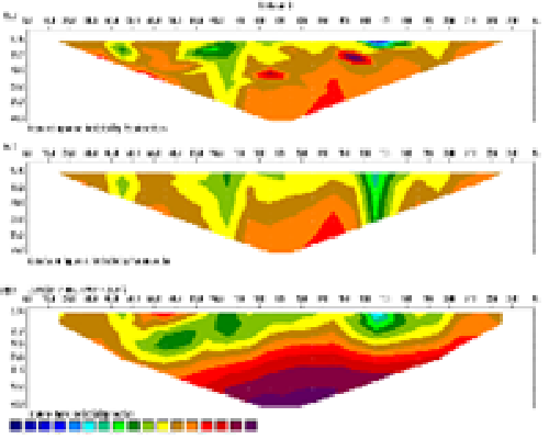
This research aims to identify sea water intrusion in groundwater using the Wenner-Schlumberger configuration (2D) resistivity geolectric method on Balu Island, Santiri village, Tiworo Utara sub-District, West Muna Regency. This research uses primary data which is resistivty measurement data measured in the field aimed at identifying groundwater aquifers. The interpretation data is then reconstructed into 2D cross-sectional profile using Res2Dinv software. The results obtained in the research area show that sea water intrusion has occurred in groundwater at an average surface depth of up to 39.6 meters with low resistivity values between 0.06 – 807 Ohm-meters
References
Alfisyahrin, Ahn. (2015). Analisa Keterdapatan Air Tanah Dengan Metode Geolistrik Pada Daerah Aroppoe Kecamatan Tanete Rilau Kabupatten Barru Provinsi Sulawesi Selatan. Teknik Geologi
Aryaseta, B. 2017. Identifikasi Intrusi Air Laut Pada Air Tanah Menggunakan Metode Induced Polarization: Studi Kasus Daerah Surabaya Timur. Institute Teknologi Sepuluh November
As’ari Dkk. 2020. Investigasi Sebaran Lumpur Panas Menggunakan Metode Geolistrik Tahanan Jenis Konfigurasi Dipol-Dipol Di Desa Karumenga Sebagai Mitigasi Bencana Alam. Jurnal Mipa. 9(1). 14-17.Muallifah, F.,2009. Perancangan Dan Pembuatan Alat Ukur Resistivitas Tanah. Jurnal Neutrino. 2(1). 179-197.
Astutik, P., Wahyono, S.C., and Siregar, S.S., 2016. Identifikasi Intrusi Air Laut Menggunakan Metode Geolistrik Di Desa Kampung Baru, Tanah Bumbu. Jurnal Fisika FLUX, 13(2), 155-160.
Bukhari, Saputra, A. D., Pratama, A. H., Abdullah, F., Yanis, M. dan Ismail, N., 2017, Identifikasi struktur berpotensi longsor berdasarkan model resistivitas listrik 2D, Prosiding Semirata 2017 Bidang MIPA BKS-PTN Wilayah Barat, ISBN: 978-602-50593-0-8, 942-953.
Darsono, Legowo, B., dan Koesuma, S. (2016) Identification of aquifer potential by using resistivity method: A case study in Kedawung and Sambirejo district, Sragen, Central Java, Indonesia. Journal of Physics: Conference Series. 776 (2016), 012121.
Gijoh, Ofvelia Thirsha, dkk. 2017. Identifikasi Akuifer Air Tanah Menggunakan Metode Geolistrik Tahanan Jenis Konfigurasi Dipole-Dipole di Masjid Kampus Universitas Sam Ratulangi. Jurnal Mipa UNSRAT. Vol. 6 No. 1.
Ismawan. Dkk. 2016 Kajian Intrusi Air Laut Dan Dampaknya Terhadap Masyarakat Di Pesisir Kota Tegal.jurnal geo image.5(1)2252-6285.
Pujianiki, N. N., Dharma, I. G. B. S., & Wijayantari, I. A. M., 2019. Analisis Intrusi Air Laut pada Sumur Gali di Kawasan Candidasa Karangasem. Spektran, 7(1), 105–114.
Santoso. 2016. Penerapan metode Geolistrik 2D untuk identifikasi amblasan tanah dan longsoran di jalan tol Semarang.
Seyhan, E. 1990. Dasar-dasar Hidrologi. Terjemahan Fundamental of Hydrology. Subagyo,S, Yogyakarta: Gadjah Mada Press.
Sikumbang. dkk, 1995, Peta Geologi Lembar Buton, Pusat Penelitian dan Pengembangan Geologi, Bandung.
Telford, W. M., Geldart, L. P., Sheriff, R.E. (1990). Applied Geophysics, Second.
Downloads
Published
How to Cite
Issue
Section
License
Copyright (c) 2024 Jurnal Rekayasa Geofisika Indonesia

This work is licensed under a Creative Commons Attribution 4.0 International License.