Implementation Of Matrix Laboratory In Microtremor Data Processing Using Hvsr Method: A Case Study In The Coastal Area Of Moramo Sub-District
DOI:
https://doi.org/10.56099/jrgi.v6i02.48Keywords:
Microtremor, HVSR, MATLAB, Mapping ToolboxAbstract
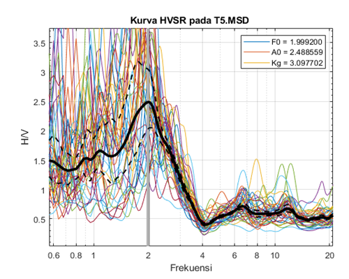
Vibration characteristics in a region of the earth are strongly influenced by unique physical and geological parameters, resulting in diverse responses to natural and anthropogenic disturbances. This research not only contributes to the understanding of geology and vibration response, but also presents a methodology that can be widely applied in passive seismic research. The analysis method in this study uses MATLAB programming language for microtremor signal processing. The algorithm of this research is able to produce a model that reveals the frequency and statistical characteristics of the microtremor signal, the output is quite similar to the open-source software GEOPSY in HVSR processing. There are 15 research data with type .msd as a representation of 15 measurement points scattered in Moramo sub-district. The statistics obtained show that the dominant ground frequency (F0), amplification factor (A0), and seismic susceptibility index (Kg) in the Coastal Land of Moramo Subdistrict range from 0.519792 - 14.692654 Hz, 2.250096 - 6.370357 times amplification, and 0.500194 - 50.516144 s²/cm, respectively. These results are quite similar to previous research by RIVAL (2023) who used GEOPSY software as his analysis tool. The statistical distribution in the form of dominant frequency (F0), amplification (A0) and seismic susceptibility index (Kg) were then interpolated and overlaid with the geodata of the study area using the Mapping Toolbox which is also in the MATLAB environment.References
Akbar, R., Darman, R., Marizka., Namora, J., & Ardewati, N. (2018). Implementasi Business Intelligence Menentukan Daerah Rawan Gempa Bumi di Indonesia dengan Fitur Geolokasi. Jurnal Edukasi dan Penelitian Informatika, 4(1), 30.
Arintalofa, V., Yulianto, G., & Harmoko, U. (2020). Analisa Mikrotremor Menggunakan Metode HVSR untuk Mengetahui Karakteristik Bawah Permukaan Manifestasi Panas Bumi Diwak dan Derekan Berdasarkan Nilai Vp. Jurnal Energi Baru dan Terbarukan, 1(2), 54-61. https://doi.org/10.14710/jebt.2020.9276
BNPB. (2021). Kajian Risiko Bencana Nasional Provinsi Sulawesi Tenggara 2022-2026. Direktorat Pemetaan danEvaluasi Risiko Bencana.
Farida, F. (2017). Optimasi Lowpass Filter Mikrostrip Frekuensi 10,6 GHz dengan Metode Step-Impedansi. Jurnal Sustainable: Jurnal Hasil Penelitian dan Industri Terapan, Vol. 06, No.02, hal. 89- 95.
François Beauducel. (2023). RDMSEED and MKMSEED: Read and write miniSEED files (https://github.com/IPGP/mseed-lib), GitHub
Hartati, Lidia. (2014). Pemetaan Tingkat Resiko Gempabumi Daerah Liwa dan Sekitarnya Berdasarkan Pengukuran Mikrotremor. Thesis. Yogyakarta : UGM.
Konno, K & Ohmachi, T. (1998). Ground Motion Characteristics Estimated from Spectral Ratio beetwen Horizontal and Vertical Components of Microtremor. Bull. Seism. Soc. Am. 88, 228–241. https://doi.org/10.1785/BSSA0880010228
Kusuma, DT. (2021). Fast Fourier Transform (FFT) Dalam Transformasi Sinyal Frekuensi Suara Sebagai Upaya Perolehan Average Energy (AE) Musik. Jurnal Pengkajian dan Penerapan Teknik Informatika. Vol. 14, No.1. https://doi.org/10.33322/petir.v14i1.1022
Marjiyono. (2010). Estimasi Karakteristik Dinamika Tanah Dari Data Mikrotremor Wilayah Bandung. Thesis ITB. Bandung.
Nakamura, Y. (1989). A Method for Dynamic Characteristics Estimation of Subsurface using Microtremor on the Ground Surface. Japan: Quarterly Report of Railway Technical Research Institute (RTRI), Vol. 30, No.1.
Nakamura, Y. (2000). Clear Identification of Fundamental Idea of Nakamura’s Technique and Its Application. Japan: Tokyo University.
Ngadmanto, D., Susilanto, P., Nurdiyan, B., Pakpahan, S., & Masturyono. (2013). Efek Tapak Lokal Daerah Kerusakan Akibat Gempa Bumi. https://doi.org/10.31172/jmg.v14i3.162
Rahmaningtyas, Aindya Putri. (2017). Identifikasi Percepatan Tanah Maksimum (PGA) dan Kerentanan Seismik Menggunakan Metode Mikrotremor di Jalur Sesar Kendeng. Skripsi Surabaya: Departemen Teknik Geofisika Institut Teknologi Sepuluh Nopember. http://dx.doi.org/10.12962/j25023659.v3i2.2966
Rival. (2023). Mikrozinasi Indeks Kerentanan Seismik Berdasarkan analisis HVSR Data Mikrotremor di Daratan Pesisir Kecamatan Moramo Kabupaten Konawe Selatan. Kendari: Universitas Halu Oleo
Shi, Jian. (2013). A Python Library That Performs Konno-Ohmachi Filtering Very Fast. https://pypi.org/project/fast-konno-ohmachi/
Siregar, I.S., Madlazim. (2017). Analisis Mikrotremor dengan Metode HVSR untuk Mengetahui Zona Penguatan Gempa Bumi di Wilayah Stasiun Seismik Jawa Timur. Jurnal Inovasi Fisika Indonesia (IFI), Vol. 06 No. 03.
Syafril. (2019). Statistik Pendidikan. Jakarta: Kencana (Prenadamedia Group).
Tokimatsu, K. (2004). S-wave velocity profiling by inversion of microtremor H/V spectrum. Bulletin of the Seismological Society of America No.94(1).
Wang, P. (2020). Predictability and repeatability of non-ergodic site response for diverse geological conditions, PhD The- sis, UCLA, Dept. Civil Engineering, 210 p
Downloads
Published
How to Cite
Issue
Section
License
Copyright (c) 2024 Jurnal Rekayasa Geofisika Indonesia

This work is licensed under a Creative Commons Attribution 4.0 International License.