Identification of Subsurface Geological Structure Configuration Based on Gravity Field Anomaly Data With Edge Detection and Euler Deconvolution Techniques In The Lainea Geothermal Area
DOI:
https://doi.org/10.56099/jrgi.v6i01.61Keywords:
Lainea geothermal area, edge detection, euler deconvolutionAbstract
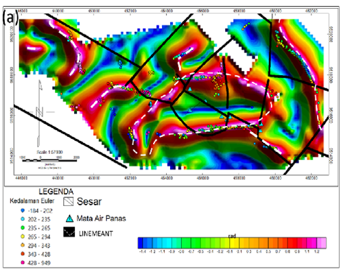
this research is located in Lainea District, Lainea Village, Southeast Sulawesi, which aims to determine the subsurface structure based on the edge detection technique and determine the depth of the anomaly source using euler deconvolution. Fault segmentation with varying trends and depths illustrates the complexity of tectonic activity around the research area. The application of several edge detection techniques to the residual anomaly data shows the superiority of the TAHG approach in identifying the edges of geothermal source zones and the alignment of geological structures while the TDX approach only shows the boundaries of the anomalies. The euler deconvolution depth solution shows that the faults generated from the TAHG approach belong to shallow faults.
References
Ferreira, F. J. F., de Souza, J., Bongiolo, A. de B. e. S., & de Castro, L. G. (2013). Enhancement of the total horizontal gradient of magnetic anomalies using the tilt angle. Geophysics, 78(3), J33–J41. https://doi.org/10.1190/geo2011-0441.1
Grauch, V. J. S., & Cordell, L. (1987). Limitations of determining density or magnetic boundaries from the horizontal gradient of gravity or pseudogravity data. Geophysics, 52(1), 118–121. https://doi.org/10.1190/1.1442236
Kasbani. (2009). Sumber Daya Panas Bumi Indonesia: Status Penyelidikan, Potensi dan Tipe Sistem Panas Bumi. In Buletin Sumber Daya Geologi (Vol. 4, Issue 3, pp. 19–26).
Prasad, K. N. D., Pham, L. T., Singh, A. P., Eldosouky, A. M., Abdelrahman, K., Fnais, M. S., & Gómez-Ortiz, D. (2022). A Novel Enhanced Total Gradient (ETG) for Interpretation of Magnetic Data. Minerals, 12(11). https://doi.org/10.3390/min12111468
PSDG. (2010). Laporan Akhir Survei geofisika terpadu gaya berat, geomagnet, geolistrik, daerah panas bumi lainea kabupaten konawe selatan provinsi sulawesi tenggara. 6(Desember), 128.
Safani, J., Ibrahim, K., Deni, W., Rubaiyn, A., Firdaus, F., & Harisma, H. (2023). Interpreting structural configuration of the Sengkang Basin of Indonesia using edge detection and 3-D Euler deconvolution to satellite gravity data. Turkish Journal of Earth Sciences, 32(7), 894–914. https://doi.org/10.55730/1300-0985.1881
Safani, J., Rubaiyn, A., & Lanata, R. R. (2020). Pengantar Metode Ekplorasi Gravitasi (Issue 1).
Downloads
Published
How to Cite
Issue
Section
License
Copyright (c) 2024 Jurnal Rekayasa Geofisika Indonesia

This work is licensed under a Creative Commons Attribution 4.0 International License.