Geological Structure Analysis of the Lainea Geothermal Area Using Edge Detection and Euler Deconvolution Techniques from GGMPLUS Satellite Gravity Image Data
DOI:
https://doi.org/10.56099/jrgi.v7i01.62Keywords:
Panas bumi Lainea, Sesar, Deteksi Tepi, Dekonvolusi Euler, Citra GGMPlusAbstract
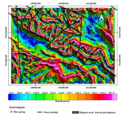
Lainea geothermal is one of the potential geothermal areas located in Southeast Sulawesi Province, South Konawe Regency. The geothermal system in this area is controlled by geological structures in the form of faults, including the Amowolo Fault, Lainea Fault, and Rumbalaka Fault (horizontal shear force). This research aims to determine the subsurface geological structure, especially faults, through the analysis of edge detection and Euler deconvolution methods using gravity data from GGMPlus (Global Gravity Model Plus). The data used is gravity disturbance data in the form of free-air anomalies, which are then corrected with Bouguer correction and terrain correction to obtain complete Bouguer anomalies. Then the anomaly separation process is carried out with the upward continuation method, where the residual anomaly is upward to an altitude of 700 meters. Next, edge detection is performed using the Normalized Horizontal Tilt (TDX), and Tilt Angle of Horizontal Gradient (TAHG) methods as well as Euler deconvolution on the residual anomaly data. The results of the analysis show that the subsurface geological structure (fault alignment) of the research area based on gravity data is very good through the edge detection method in the form of TAHG filter with the alleged alignment pattern of the southwest - northeast oriented fault structure as well as the northwest - southeast oriented fault structure. While the TDX filter is good at determining anomalous contact bricks (anomalous objects. The resulting euler deconvolution depth value solution ranges from 74.2m - 257.5m..
References
Asma. (2021). Identifikasi Zona Sesar Berdasarkan Analisis Data Anomali Medan Magnet Di Daerah Lainea, Kabupaten Konawe Selatan, Sulawesi Tenggara Asma R1A117004 Jurusan Teknik Geofisika Universitas Halu Oleo Kendari Januari 2022.
Blakely, R. J. (1996). Potential Theory in Gravity and Magnetic. In Cambridge University Press.
Cooper, G. R. J., & Cowan, D. R. (2006). Enhancing potential field data using filters based on the local phase. Computers & Geosciences, 32(10), 1585-1591. https://doi.org/10.1016/j.cageo.2006.02.016
Eldosouky, A. M., Pham, L. T., Mohmed, H., & Pradhan, B. (2020). A comparative study of THG, AS, TA, Theta, TDX and LTHG techniques for improving source boundaries detection of magnetic data using synthetic models: A case study from G. Um Monqul, North Eastern Desert, Egypt. Journal of African Earth Sciences, 170, 103940. https://doi.org/10.1016/j.jafrearsci.2020.103940
Febyanti, T., Hamimu, L., & Asvar, A. R. S. (2022). Pemodelan 3d Reservoar Panasbumi Non-Vulkanik Menggunakan Metode Geomagnetik Di Daerah Lainea Kabupaten Konawe Selatan Provinsi Sulawesi Tenggara. Jurnal Rekayasa Geofisika Indonesia, 4, 120-129.
Ferreira, F. J. F., de Souza, J., Bongiolo, A. de B. e. S., & de Castro, L. G. (2013). Enhancement of the total horizontal gradient of magnetic anomalies using the tilt angle. Geophysics, 78(3), J33–J41. https://doi.org/10.1190/geo2011-0441.1
Grand, F. S. dan West, G.F., 1965, Interpretation Theory in Applied Geophysics, Me Graw Hill, New York.
Hadi, M. N., Kusniadi, D., & Widodo, S. (2010). Laporan Akhir Penyelidikan Terpadu Geologi dan Geokimia Daerah Panas Bumi Lainea. http://psdg.bgl.esdm.go.id/perpus/alihmedia/LS20104PB/
Hirt, C., Claessens, S., Fecher, T., Kuhn, M., Pail, R., & Rexer, M. (2013). New ultrahigh-resolution picture of Earth’s gravity field. Geophysical Research Letters, 40(16), 4279–4283. https://doi.org/10.1002/grl.5083 8
Hinze,William.J., Ralph R. B. von Frese., A. H. S. (2013. Gravity and Magnetic Exploration. 69
Hochstein, M. P., & Sudarman, S. (2008). History of geothermal exploration in Indonesia from 1970 to 2000. Geothermics, 37(3), 220-266. https://doi.org/https://doi.org/10.1016/j.geothermics.2008.01.001
Kane, M.F., 1962, A Comprehensive System of Terrain Correction Using a Digital Computer, Geophysics, 27 (4), hal. 455-462.
Pham, L. T., Oksum, E., & Dolmaz, M. N. (2021). GRV_D_inv : A graphical user interface for 3D forward and inverse modeling of gravity data. Geofizicheskiy Zhurnal, (43(1), 181-193. https://doi.org/10.24028/gzh.02033100.v43il.2021.225546
Pham, L. T., Ghomsi, F. E. K., Vu, T. Van, Oksum, E., Steffen, R., & Tenzer, R. (2023). Mapping the structural configuration of the western Gulf of Guinea using advanced gravity interpretation methods. Physics and Chemistry of the Earth, 129(December 2022), 103341. https://doi.org/10.1016/j.pce.2022.103341
Prasad, K. N. D., Pham, L. T., Singh, A. P., Eldosouky, A. M., Abdelrahman, K., Fnais, M. S., & Gómez-Ortiz, D. (2022). A Novel Enhanced Total Gradient (ETG) for Interpretation of Magnetic Data. Minerals, 12(11). https://doi.org/10.3390/min12111468 .
Reid, A. B., Allsop, J. M., Granser, H., Millet, A. J., & Somerton, I. W. (1990). To: “Magnetic interpretation in three dimensions using Euler deconvolution,” by A. B. Reid, J. M. Allsop, H. Granser, A. J. Millett, and I. W. Somerton (G EOPHYSICS , p. 80–91, January 1990) . Geophysics, 55(4), 502–502. https://doi.org/10.1190/1.1442861
Safani, J., (2020). Pengantar Metode Ekplorasi Gravitasi (Issue 1).
Salem, A., Elawadi, E., & Ushijima, K. (2003). Depth determination from residual gravity anomaly data using a simple formula. Computers and Geosciences, 29(6), 801–804. https://doi.org/10.1016/S0098-3004(03)00106-7
Simanjundtak, TO., Surono, Hadiwijoyo, S. (1993). Geologi Lembar Kolaka. Geologi, 1(August), 117-125.
Surono, 2013, Geologi Lengan Tenggara Sulawesi, Badan Geologi Kementerian Energi dan Sumber Daya Mineral. Bandung
Telford, W. M., Geldart, L. P., & Sheriff, R. E. (1990). Applied geophysics. 2nd edition. In Applied geophysics. 2nd edition.
Verduzco, B., Fairhead, J. D., Green, C. M., & MacKenzie, C. (2004). New insights into magnetic derivatives for structural mapping. Leading Edge (Tulsa, OK), 23(2), 116–119. https://doi.org/10.1190/1.1651454
Wijns, C., Perez, C., & Kowalczyk, P. (2005). Short Note Theta map : Edge detection in magnetic data. 70(4), 39–44.
Zakir, M. N. A. (2021). Interpretasi struktur geologi daerah Selatan Pulau Buton Menggunakan Data Gravitasi Satelit Ggmplus. 3(1).
Downloads
Published
How to Cite
Issue
Section
License
Copyright (c) 2025 Jurnal Rekayasa Geofisika Indonesia

This work is licensed under a Creative Commons Attribution 4.0 International License.