HVSR Ground Shear Strain Analysis to Identify Potency of Ground Movement at Kadia District, Kendari City
DOI:
https://doi.org/10.56099/jrgi.v6i02.79Keywords:
Ground Shear Strain, Peak Ground Acceleration, Seismic Vulnerability Index, HVSR, MicrotremorAbstract
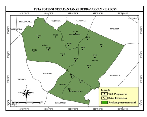
This research on Ground Shear Strain (GSS) was carried out to determine the potential for ground movements in Kadia District, Kendari City. In its implementation, GSS is processed using microtremor data from measurements in the field. GSS is the result of multiplying the Seismic Vulnerability Index (Kg) and the basement Peak Ground Acceleration (PGA). Microtremor data were taken at 16 measurement points with a distance between measurement points of 400 to 600 m. The microtremor data were then analyzed using the HVSR (Horizontal to Vertical Spectral Ratio) method available in Geopsy 3.3.6 software to obtain predominant frequency values (fo) and amplification factors (Ao). These two parameters are used to calculate the Kg value. The PGA value is determined using the Fukushima and Tanaka empirical formula using earthquake data with a depth of ≤ 50 km and surface magnitude (MS) ≥ 5 SR. The research results show that the GSS values in Kadia District, Kendari City ranges from 1.1768x10⁻⁴ to 6.5436x10⁻⁴. Based on the results of ground movement analysis, it is known that Kadia District, Kendari City, has the potential to experience cracks or land subsidence if an earthquake occurs with elasto-plastic soil dynamics. Apart from that, it is also known that the Kadia District area of Kendari City is not prone to landslides and liquefaction because g < 10-2.
References
BPS Kota Kendari. (2019): Kota Kendari dalam Angka 2019. https://kendarikota.bps.go.id/
Campbell, K. W. & Bozorgnia, Y. (2003). Updated Near-Source Ground-Motion (Attenuation) Relations for the Horizontal and Vertical Components of Peak Ground Acceleration and Acceleration Response Spectra. Bulletin of the Seismological Society of America. 93(1), 314–331.
Chahyani, R., Manan, A., Puspitafuri, C., & Kasmawati. (2020). Identification of surface-basement layer distribution of Wangi-Wangi Island based on HVSR method of microtremor data. J. Phys.: Theor. Appl., 4(2), 94–101. DOI: 10.20961/jphystheor-appl.v4i2.48727
Daryono, S. (2013). Indeks kerentanan seismik berdasarkan mikrotremor pada setiap satuan bentuk lahan di zona Graben Bantul, Daerah Istimewa Yogyakarta. Jurnal Riset Daerah, 12(1).
Farid, M., & Mase, L.Z. (2020). Implementation of seismic hazard mitigation on the basis of ground shear strain indicator for spatial plan of Bengkulu city Indonesia. GEOMATE Journal 18(69), 199–207. DOI: 10.21660/2020.69.24759
Farid, M., & Hadi, A.I. (2018). Measurement of shear strain in map liquefaction area for earthquake mitigation in Bengkulu city. TELKOMNIKA 16(4), 1597–1606. DOI: 10.12928/telkomnika.v16i4.8043
Farid, M., & Suryanto, W. (2016). Microseismic wave measurements to detect landslides in Bengkulu shore with attenuation coefficient and shear strain indicator. KnE Engineering, 1–7. DOI: 10.18502/keg.v1i1.477
Fatimah, R., Ardian onasi gempabumi di Desa Medana dan to, T., & Qomariyah, N. (2019). Mikroz Jenggala Kecamatan Tanjung Kabupaten Lombok Utara menggunakan metode mikroseismik. Indonesian Physical Review, 2(1), 18.
Fukushima, Y., & Tanaka, T. (1990). A new attenuation relation for peak horizontal acceleration of strong earthquake ground motion in Japan. Bull. Seism. Soc. Am. 80(4), 757–783. DOI: 10.1785/BSSA0800040757
Gurler, E. D., Nakamura, Y., Saita, J., & Sato, T. (2000). Local Site Effects of Mexico City Based on Microtremor Measurement. 6th International Conference on Seismic Zonation, Palm Spring Riviera Resort, California, USA, Pp. 65.
Ishihara, K. (1986): Geomechanical Modelling in Engineering Practice, 1st ed. CRC Press, Devon.
Manan, A., Puspitafuri, C., Chahyani, R., Irawati, & Pertiwi, I.I. (2023a). Identification of shear strain on the surface ground of Wangi-Wangi island, Southeast Sulawesi, Indonesia, using Nakamura’s technique and the possibility of it impacts. Journal of Geoscience, Engineering, Environment, and Technology (JGEET), 8(4), 276–81. DOI: 10.25299/jgeet.2023.8.4.11780
Manan, A., Puspitafuri, C., Pertiwi, I.I., & Chahyani, R. (2023b). Identification of Peak Ground Acceleration and hazard potency of earthquake disaster on the mainland surface of Wangi-Wangi Island, Wakatobi Regency, Southeast Sulawesi, Indonesia. J. Phys.: Conf. Ser., 1–9. DOI: 10.1088/1742-6596/2498/1/012040
Manan, A., Puspitafury, C., Kasmawati, & Pertiwi, I.I. (2021). Identifikasi potensi kerusakan akibat gempabumi berdasarkan Indeks Kerentanan Seismik data mikrotremor di Pulau Wangi-Wangi. Jurnal Formasi, 6(2), 01–11.
Marjiyono., Soehaimi, A., & Setiawan. J. H. (2007). Mikrozonasi daerah Kendari dan sekitarnya berdasarkan respons tanah setempat. JSDG XVII(1), 49.
Nakamura, Y. (2000): Clear Indentification of Fundamental Idea of Nakamura’s Technique and Its Application. Tokyo University. Japan.
Petermans, T., Devleeschouwer, X., & Pouriel, F. (2006). Mapping the local seismic hazard in the urban area of Brussels, Belgium. Proceedings of the 10th IAEG Congress, International Association for Engineering Geology, (424), 1-11.
Sasongko, D. P., Yuliyanto, G., & Arifin, Z. (2019). Vibration vulnerability identification in Kota Lama Semarang using microtremor method. Indonesian Journal of Applied Physics, 9(2), 105–111.
SESAME. (2004): Guidelines For The Implementation Of The H/V Spectral Ratio Technique on Ambient Vibrations, Europe. SESAME European Research Project.
Surono. (2013): Geologi Lengan Tenggara Sulawesi. Badan Geologi, Kementerian Energi dan Sumber Daya Mineral. Jakarta.
Surono, & Hartono, U. (2013): Geologi Sulawesi. LIPI Press, Jakarta.
Downloads
Published
How to Cite
Issue
Section
License
Copyright (c) 2024 Jurnal Rekayasa Geofisika Indonesia

This work is licensed under a Creative Commons Attribution 4.0 International License.