
The Deep Crustal Structure Beneath The Central Part of Sumatran Island From Ambient Seismic Noise Tomography
DOI:
https://doi.org/10.56099/jrgi.v6i03.140Keywords:
Ambient Noise Tomography (ANT), magmatisme, diapir mantelAbstract
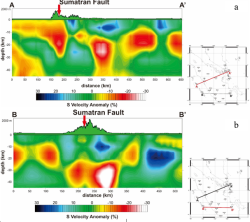
The distribution of earthquake epicenter locations along the island of Sumatra is more concentrated in the fore-arc zone, this causes the resulting model resolution to be less good for the back-arc zone. The Ambient Seismic Noise Tomography (ANT) method provides an alternative to increase the resolution of the tomographic images obtained because it no longer depends on the distribution of earthquake locations, but only depends on the distribution of seismic observation stations on the surface. This research aims to obtain the structure of the deep crust based on the distribution of shear velocity (Vs) from the fore arc to the back arc zone in the central part of Sumatra Island. The data used is waveform recorded during April - December 2015. The dispersive signal is clearly visible in the gather data for a period ranging from 5 - 40 s, an average group speed between 2.77 - 2.92 km/s and an average phase speed between 3.18 – 4.50 km/s. ANT results at a depth of less than 30 km imaged a high speed anomaly pattern along the Sumatran Fault zone and the Bukit Barisan Volcano range which was interpreted as residual material from the magmatism process. Meanwhile, the back-arc basin area is dominated by velocities with a range of medium to low values which are interpreted as sedimentary units. At a depth of more than 30 km there is a low anomalous contrast along the Sumatran Fault zone which is indicated as a mantle diapir developing in the study area.
References
Fang, H., Yao, H., Zhang, H., Huang, Y. C., & van der Hilst, R. D. (2015). Direct inversion of surface wave dispersion for three-dimensional shallow crustal structure based on ray tracing: methodology and application. Geophysical Journal International, 201(3), 1251-1263
Fitch, T. J., Plate convergence, transcurrent faults, and internal deformation adjacent to southeast Asia and the western Pacific, J. Geophys, Res., 77, 4432-4462, 1972.
Harmon, N., Henstock, T., Tilmann, F., Rietbrock, A., Barton, P. (2012): Shear velocity structure across the Sumatran Forearc-Arc. - Geophysical Journal International, 189, 3, pp. 1306—1314.
Lin, F., M.P. Moschetti, and M.H. Ritzwoller, (2008): Surface wave tomography of the western United States from ambient seismic noise: Rayleigh and Love wave phase velocity maps, Geophys. J. Int.,doi:10.1111/j1365-246X.2008.03720.x
Muraoka, H., Takahashi, M., Sundhoro, H., Dwipa, S., Soeda, Y., Momita, M., and Shimada, K., 2010, Geothermal Systems Constrained by the Sumatran Fault and Its Pull-Apart Basins in Sumatra, Western Indonesia, Proceedings World GeothermalCongress2010 Bali, Indonesia, 25-29 April 2010
Sieh, K., and Natawidjaja, D.H., (2000): Neotectonics of the Sumatran fault, Indonesia, J. geophys. Res.,105,28 295–228 326
Wang, Y., Fan-Chi Lin, Schmandt, B., and Farrell, J., (2017): Ambient noise Tomography across Mount St. Helens using a dense seismic array, AGU, doi: 10.1002/2016JB013769
Yao, H., van der Hilst R.D., and de Hoop, M.V., 2006. Surface-wave array tomography in SE
Tibet from ambient seismic noise and two-station analysis : I - Phase velocity maps. Geophys.J. Int., Vol. 166(2), 732-744, doi: 10.1111/j.1365-246X.2006.03028.x.
Downloads
Published
How to Cite
Issue
Section
License
Copyright (c) 2024 Jurnal Rekayasa Geofisika Indonesia

This work is licensed under a Creative Commons Attribution 4.0 International License.