Identification of Potential Earthquake Damage Levels Based on the Seismic Vulnerability Index Using the HVSR Method in Kadia District, Kendari City
DOI:
https://doi.org/10.56099/jrgi.v5i01.16Keywords:
Seismic vulnerability index, HVSR, microtremor, ground shaking, Kadia DistrictAbstract
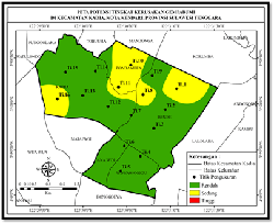
This research was conducted to identify the potential level of earthquake damage in Kadia District, Kendari City. The potential level of damage is known based on the seismic vulnerability index parameter. The data used is microtremor data obtained from the results of the frequency filtering process of ground vibration data using a Band Pass Filter type with a frequency range of 1.00 to 25.00 Hz. While the ground vibration data was obtained from the results of direct measurements in the field at 16 measurement points using 1 set of portable seismograph TDL 303S. Furthermore, the data is processed using the Horizontal to Vertical Spectral Ratio (HVSR) method to produce the dominant frequency of the soil and the amplification factor used to calculate the seismic vulnerability index. From the results of data processing carried out scientifically in Kadia District, Kendari City, a seismic vulnerability index value was obtained with values ranging from 0.761 to 5.292 /cm. Based on the results of mapping of the potential level of earthquake damage obtained from the results of the seismic vulnerability index value, it shows that Kadia District, Kendari City has a low to moderate potential for damage due to earthquakes. Low zones with seismic vulnerability index values < 3 are scattered in Kadia, Bende, Anaiwoi, and Wowawanggu Villages. Moderate zones with seismic vulnerability index values < 3 to 6 are scattered in Kadia, Pondambea, and Bende Villages.
References
Arifin, S. S., Mulyatno, B. S., Marjiyono, & Setianegara, R. Penentuan Zona Rawan Guncangan Bencana Gempabumi Berdasarkan Analisis Nilai Amplifikasi HVSR Mikrotremor dan Analisis Periode Dominan Daerah Liwa dan Sekitarnya. Jurnal Geofisika Eksplorasi, 2(1), (2014).
Kanai, K. Seismology in Engineering. Tokyo University. Japan, (1998).
Konno, K., & Ohmachi, T. Ground-motion Characteristics Estimated From Spectral Ratio Between Horizontal and Vertical Components of Microtremor. Bulletin of the Seismological Society of America, 88(1), (1998) 228–241.
Lachet, C., & Bard, P. Y. Numerical and Theoretical Investigations on the Possibilities and Limitations of Nakamura’s Technique. Journal of Physics of the Earth, 42(5), (1994) 377–397.
Lantu, Aswad, S., Fitriani, & Marjiyono. Pemetaan Wilayah Rawan Bencana Gempabumi Berdasarkan Data Mikrotremor dan Data Bor. Jurnal Geocelebes, 2(1), (2018) 20–30.
Maimun, A. K., Silvia, U. N., J, V. J., & Ariyanto, P. Analisis Indeks Kerentanan Seismik, Periode Dominan, dan Faktor Amplifikasi Menggunakan Metode HVSR di Stageof Tangerang. Jurnal Meteorologi Klimatologi Dan Geofisika, 7(2), (2020) 24–30.
Nakamura, Yutaka. A method for dynamic characteristics estimation of subsurface using microtremor on the ground surface. Railway Technical Research Institute, Quarterly Reports, 30(1), (1989).
Nakamura, Yutaka. Clear Identification of Fundamental Idea of Nakamura ’ S Technique And ITS Applications. (2000).
Nakamura, Y. On The H/V Spectrum, The 14th World Conference on Earthquake Engineering. October. (2008).
Nur, A. M. Gempa Bumi, Tsunami Dan Mitigasinya. 7(1), (2010) 66–73.
Pratama, I. P. D., & Koten, M. C. R. Klasifikasi Kelas Tanah dan Indeks Kerentanan Seismik pada Lokasi Jaringan Sensor Seismik di Bali dan Nusa Tenggara. 6(2), (2021) 90–101.
Refrizon, Hadi, A. I., Lestari, K., & Oktari, T. Analisis Percepatan Getaran Tanah Maksimum dan Tingkat Kerentanan Seismik Daerah Ratu Agung Kota Bengkulu (pp. 323–328). Lampung: Prosiding Seminar FMIPA Universitas Lampung. (2013).
Simanjuntak, A. B., Yuliyanto, G., & Harmoko, D. U. Analisis Resiko Kebencanaan Gempabumi data mikrotremor di Desa Fulolo Kecamatan Alasa Kabupaten Nias Utara. Youngster Physics Journal, 6(4), (2017) 360–367.
Soehaimi, A., Marjiyono, & Setiawan, J. Mikrozonasi Daerah Kendari dan Sekitarnya Berdasarkan Respons Tanah Setempat. Jurnal Geologi Dan Sumberdaya Mineral, XVII. (2007).
Tanjung, N. A. F., Yuniarto, H. P., & Widyawarman, D. Analisis Amplifikasi Dan Indeks Kerentanan Seismik Di Kawasan FMIP UGM Menggunakan Metode HVSR. Jurnal Geosaintek, 5(2), (2019) 60.
www.bmkg.go.id
Downloads
Published
How to Cite
Issue
Section
License
Copyright (c) 2023 Jurnal Rekayasa Geofisika Indonesia

This work is licensed under a Creative Commons Attribution 4.0 International License.