Simulation of Significant Wave Height in The Makassar Strait in January-February 2016
DOI:
https://doi.org/10.56099/jrgi.v5i03.30Keywords:
Gelombang, Selat Makassar, Pemodelan GelombangAbstract
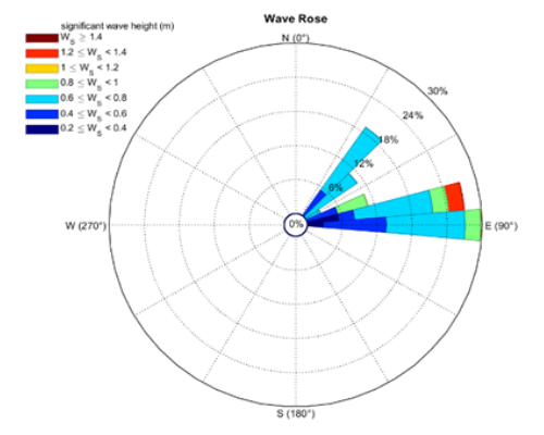
Knowledge of the characteristics of sea waves is very important for many maritime fields such as shipping safety, offshore industry, coastal area development, defense, and ship design. As the largest maritime country in the world, Indonesia is vulnerable to high sea waves. BMKG adopts the third generation wave model, namely WAVEWATCH-III which was developed by NOAA, USA. This model is used to predict the height and direction of sea waves in Indonesian waters. The purpose of this study is to determine the characteristics of the results of the WAVEWATCH-III wave model in the Makassar Strait. In January-February 2016 significant sea wave heights ranged from 0 m to 1.5 m and the direction of the waves came from the northeast in the Makassar Strait. Significant wave heights in January-February 2016 were not at a level that endangered shipping lanes in the Makassar Strait area.
Keywords: Ocean Waves, Makassar Strait, Wave Model.
References
Ahrens, C. Donald. 2007. Meteorology Today, Cengage Learning, USA.
CERC, 2010. Shore Protection Manual, U.S. Army Corps of Engineers. Coastal Engineering Research Center. Washington.
Pariwono dan Manan, 1991. Angin. O. S. R. Ongkosongo dan Suyarso (ed). Angin, P3O-LIPI. Jakarta.
Tolman, H. L., Balasubramaniyan, B., Burroughs, L. D., Chalikov, D. V., Chao, Y. Y., Chem, H. S., et al. (2002). Development and Implementation of Wind Generated Ocean Surface Wave Models at NCEP. NCEP Notes, Journal of Atmoshpheric and Oceanic Technology, Vol. 17, 311-333.
Triatmodjo, B., 1999. Teknik Pantai. Beta Offset. Yogyakarta.
Downloads
Published
How to Cite
Issue
Section
License
Copyright (c) 2023 Jurnal Rekayasa Geofisika Indonesia

This work is licensed under a Creative Commons Attribution 4.0 International License.