Identification of Groundwater Potential on Katela Island, West Muna Regency Using the Geoelectric Resistivity Method
DOI:
https://doi.org/10.56099/jrgi.v6i01.74Keywords:
Geolistrik resistivitas, air tanah, pulau katelaAbstract
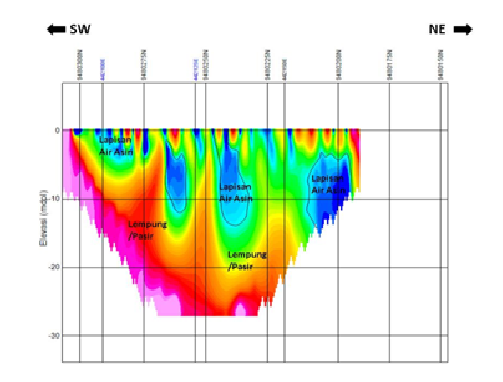
Island Katela has a population of 957 people. Currently, the community has difficulty getting clean water. Activities to identify potential groundwater resources on Katela Island need to be carried out to solve this problem. The purpose of this research activity is to identify the subsurface of the land on Katela Island, West Muna Regency using the geoelectric resistivity method to obtain information on the potential of the groundwater layer. The main objective is to determine the existence of groundwater resources on Katela Island where the presence of groundwater is depicted in 2-dimensional (2D) and 1-dimensional (1D) subsurface resistivity cross-sectional models. The results obtained show that the structure of the subsurface layers in the survey area consists of layers of clay, sand, sandstone, limestone, salt water layers and groundwater (fresh) layers. The potential existence of a groundwater layer (fresh) is at a depth of 31.25 m at Site 1, with a resistivity value above 0.2 Ωm to 1 Ωm. This layer is thought to be a fresh water layer because above it there is a layer of clay which is impermeable so it is difficult for sea water to intrude. Based on resistivity data, at shallow depths (at the surface to a depth of 25 m) in the survey area sea water has been intruded.
References
Ambarwati, R. D., 2014, Manfaat Air Bagi Kehidupan Manusia. Artikel Lingkungan Hidup, 4 (2), 1–6.
Jaya, L., Syadrie, M., Anus, A., Rokhim, J.R., 2022, Kabupaten Muna Barat Dalam Angka 2022, Muna Barat: BPS Muna Barat.
Kusumandari, A., 2015, Aplikasi Metode Geolistrik Resistivitas Untuk Mengidentifikasi Lapisan Akuifer di Bumi Perkemahan Ragunan Jakarta, Jakarta: UIN Syarif Hidayatullah.
Manrulu, R. H., Nurfalaq, A., Hamid, I.D., 2018, Pendugaan Sebaran Air Tanah Menggunakan Metode Geolistrik Resistivitas Konfigurasi Wenner dan Menggunakan Metode Geolistrik Resistivitas Konfigurasi Wenner dan Schlumberger di Kampus 2 Universitas Cokroaminoto Palopo, http://ppjp.unlam.ac.id/journal/index.php/f/.
Rosmiati S, Palloan, P., Ihsan, N., 2016, Survei Sebaran Air Tanah Dengan Metode Geolistrik Tahanan Jenis di Kelurahan Bonto Raya Kecamatan Batang Kabupaten Jeneponto, Jurnal Sains dan Pendidikan Fisika. Jilid 12, Nomor 3, Desember 2016, hal. 330 - 336, https://ojs.unm.ac.id/JSdPF/article/view/3061/1696.
Saputra, F., Baskoro, S.A., Supriyadi, Priyantari, N., 2020, Aplikasi Metode Geolistrik Resistivitas Konfigurasi Wenner dan Wenner-Schlumberger pada Daerah Mata Air Panas Kali Sengon di Desa Blawan-Ijen. Berkala Sainstek, Vol. 8, No. 1, Hal. 20-24.
Sedana, 2015, Pemetaan Air Tanah di Jalan Ringroad Kelurahan Malendeng dengan Menggunakan Metode Geolistrik Tahanan Jenis, Jurnal Ilmiah Sains: Vol. 15 No. 2, April 2015.
Suroyo, Herman, 2019, Modul 5 Desain Survei Geolistrik Untuk Air Tanah, Kementerian PUPR, Badan Pengembangan Sumber Daya Manusia, Pusat Pendidikan dan Pelatihan Sumber Daya Air dan Konstruksi Indonesia.
Telford, W.M., 1990, Applied Geophysics, London: Cambridge University Prees.
Downloads
Published
How to Cite
Issue
Section
License
Copyright (c) 2024 Jurnal Rekayasa Geofisika Indonesia

This work is licensed under a Creative Commons Attribution 4.0 International License.