Identification Identification of Submarine Pipelines Using Geomagnetic Data
DOI:
https://doi.org/10.56099/jrgi.v6i03.87Keywords:
magnetic methods, Tie Line leveling, Signal AnalysisAbstract
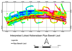
The sea pipeline network has several risks of damage caused by several causes, including ship anchors dropping, ships running aground, ships sinking, trawls, and so on. Several of these damage factors cause vertical and lateral shifts of the underwater pipeline which can cause changes in the map of the underwater pipeline that has been made. This study aims to identify the existence of underwater pipelines and determine the distribution pattern of underwater pipeline locations using the magnetic method. The magnetic data is then processed to obtain a total magnetic anomaly, then correction is made using the tie line leveling method. Further processing is carried out by applying the reduction process to the equator, then applying the analytical signal process as a strengthening of the anomaly source. The data interpretation process produces a map of the identification of the underwater pipeline route. The results of the processing show that the pipeline is located at a depth of 2 meters to 18 meters below sea level with a magnetic anomaly range of 85.16 nT to 128.11 nT
References
Cassidy, J., & Locke, C. A. (2010). The Auckland volcanic field, New Zealand: Geophysical evidence for structural and spatio-temporal relationships. Journal of Volcanology and Geothermal Research, 195(2–4), 127–137. https://doi.org/10.1016/j.jvolgeores.2010.06.016
Cooper, G. R. J., & Cowan, D. R. (2006). Enhancing potential field data using filters based on the local phase. Computers and Geosciences, 32(10), 1585–1591. https://doi.org/10.1016/j.cageo.2006.02.016
Eldosouky, A. M., Pham, L. T., Mohmed, H., & Pradhan, B. (2020). A comparative study of THG, AS, TA, Theta, TDX and LTHG techniques for improving source boundaries detection of magnetic data using synthetic models: A case study from G. Um Monqul, North Eastern Desert, Egypt. Journal of African Earth Sciences, 170, 103940. https://doi.org/10.1016/j.jafrearsci.2020.103940
Hinze, W. J., von Frese, R. R. B., & Saad, A. H. (2013). Gravity and Magnetic Exploration: Principles, Practices and Exploration.
Lghoul, M., Abd-Elhamid, H. F., Zeleňáková, M., Abdelrahman, K., Fnais, M. S., & Sbihi, K. (2023). Application of enhanced methods of gravity data analysis for mapping the subsurface structure of the bahira basin in Morocco. Frontiers in Earth Science, 11(July), 1–15. https://doi.org/10.3389/feart.2023.1225714
Mohammadzadeh, M. (2015). Interpretation of Aeromagnetic Data to Locate Buried Faults in North of Zanjan Province, Iran. Journal of Geophysics & Remote Sensing, 04(02). https://doi.org/10.4172/2169-0049.1000143
Rachmat, B., Purwanto, C., & Raharjo, P. (2016). Kajian Identifikasi Infrastruktur Jaringan Pipa Migas Bawah Laut Di Perairan Sebelah Utara Provinsi Banten. Jurnal Geologi Kelautan, 9(2), 79. https://doi.org/10.32693/jgk.9.2.2011.202
Reeh, G., & Aïfa, T. (2008). Age of the source of the Jarrafa gravity and magnetic anomalies offshore Libya and its geodynamic implications. Journal of Geodynamics, 45(4–5), 217–233. https://doi.org/10.1016/j.jog.2008.01.001
Stewart, I. C. F., & Miller, D. T. (2018). Directional tilt derivatives to enhance structural trends in aeromagnetic grids. Journal of Applied Geophysics, 159, 553–563. https://doi.org/10.1016/j.jappgeo.2018.10.004
Subarsyah, ⠀, & Albab, A. (2022). Identifikasi Pipa Bawah Laut Menggunakan Data Geomagnet, Perairan Balikpapan, Kalimantan Timur. Jurnal Geologi Kelautan, 20(2), 81–86. https://doi.org/10.32693/jgk.20.2.2022.768
Ting‐Jie, Y., Yan‐Gang, W., Yuan, Y., & Ling‐Na, C. (2016). Edge Detection of Potential Field Data Using an Enhanced Analytic Signal Tilt Angle. Chinese Journal of Geophysics, 59(4), 341–349. https://doi.org/10.1002/cjg2.20239
Wago, O. (2021). Perencanaan Jaringan Pipa Distribusi Air Bersih Di Desa Lekogoko-Ngada. Jurnal Teknik Sipil, 10(2), 163–172.
Wang, W., Pan, Y., & Qiu, Z. (2009). A new edge recognition technology based on the normalized vertical derivative of the total horizontal derivative for potential field data. Applied Geophysics, 6(3), 226–233. https://doi.org/10.1007/s11770-009-0026-x
Wibowo, I. L., & Mukhlash, I. (2017). 280121-Penilaian-Risiko-Pipa-Bawah-Laut-Oleh-Fa-Fe92Ce40. 61–71.
Downloads
Published
How to Cite
Issue
Section
License
Copyright (c) 2024 Jurnal Rekayasa Geofisika Indonesia

This work is licensed under a Creative Commons Attribution 4.0 International License.